Historical map of the temples of Karnak, Thebes, Egypt, lithograph, 1879 - stock illustration
Historical map of the three temple districts of Karnak, Thebes, Egypt. Lithograph, published in 1879.

Get this image in a variety of framing options at Photos.com.
PURCHASE A LICENCE
All Royalty-Free licences include global use rights, comprehensive protection, and simple pricing with volume discounts available
335.00 €
EUR
Getty ImagesHistorical Map Of The Temples Of Karnak Thebes Egypt Lithograph 1879 High-Res Vector Graphic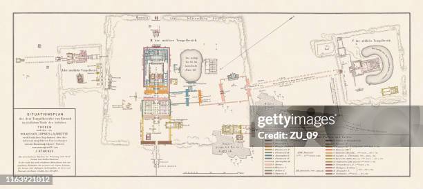 Download premium, authentic Historical map of the temples of Karnak, Thebes, Egypt, lithograph, 1879 stock illustrations from Getty Images. Explore similar high-resolution stock illustrations in our expansive visual catalogue.Product #:1163921012
Download premium, authentic Historical map of the temples of Karnak, Thebes, Egypt, lithograph, 1879 stock illustrations from Getty Images. Explore similar high-resolution stock illustrations in our expansive visual catalogue.Product #:1163921012335€50€
Getty Images
In stockDETAILS
Credit:
Creative #:
1163921012
Licence type:
Collection:
DigitalVision Vectors
Max file size:
10573 x 4729 px (89.52 x 40.04 cm) - 300 dpi - 28 MB
Upload date:
Location:
Germany
Release info:
Property released
Categories:
- Map,
- Ancient Egyptian Culture,
- Archaeology,
- Ancient,
- Ancient Civilisation,
- Ancient History,
- Antique,
- Artistic Product,
- Chromolithograph,
- Colour Image,
- Drawing - Artistic Product,
- Egypt,
- Egyptian Culture,
- Engravement,
- Famous Place,
- Germany,
- History,
- Horizontal,
- Illustration,
- Lithograph,
- Luxor - Thebes,
- Middle Eastern Culture,
- Multi Coloured,
- Old,
- Panoramic,
- Temple - Building,
- Temples of Karnak,
- The Past,
- Thebes - Egypt,
- Topographic Map,
- Topography,
- Tourism,
- Travel,
- Travel Destinations,
- Upper Egypt,
- West Asia,