Finland Vector Map Regions Isolated - stock illustration
"Detailed vector map of Finland with administrative divisions. File was created on November 6, 2012. The colors in the .eps-file are ready for print (CMYK). Included files: EPS (v8) and Hi-Res JPG (3591aa aaa 5600 px)."

Get this image in a variety of framing options at Photos.com.
PURCHASE A LICENCE
All Royalty-Free licences include global use rights, comprehensive protection, and simple pricing with volume discounts available
335.00 €
EUR
Getty ImagesFinland Vector Map Regions Isolated High-Res Vector Graphic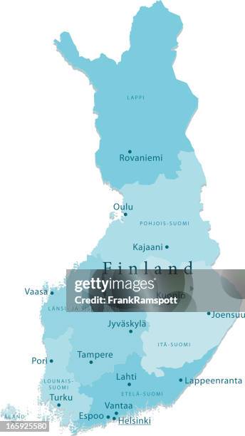 Download premium, authentic Finland Vector Map Regions Isolated stock illustrations from Getty Images. Explore similar high-resolution stock illustrations in our expansive visual catalogue.Product #:165925580
Download premium, authentic Finland Vector Map Regions Isolated stock illustrations from Getty Images. Explore similar high-resolution stock illustrations in our expansive visual catalogue.Product #:165925580335€50€
Getty Images
In stockDETAILS
Credit:
Creative #:
165925580
Licence type:
Collection:
DigitalVision Vectors
Max file size:
3061 x 5442 px (61.71 x 109.70 cm) - 126 dpi - 6 MB
Upload date:
Release info:
Model and property released
Categories:
- Map Illustrations,
- Finland Illustrations,
- Finnish Lapland Illustrations,
- Blue Illustrations,
- Cartography Illustrations,
- Clip Art Illustrations,
- Colour Image Illustrations,
- Computer Graphic Illustrations,
- Country Map Illustrations,
- Digitally Generated Image Illustrations,
- Espoo Illustrations,
- Geology Illustrations,
- Helsinki Illustrations,
- Illustration Illustrations,
- Jyväskylä Illustrations,
- Lahti - Finland Illustrations,
- No People Illustrations,
- Non-Urban Scene Illustrations,
- Nordic Countries Illustrations,
- Northern Europe Illustrations,
- Oulu - Finland Illustrations,
- Plain Background Illustrations,
- Tampere - Finland Illustrations,
- Turku - Finland Illustrations,
- Vantaa - Finland Illustrations,
- Vector Illustrations,
- Vertical Illustrations,
- White Background Illustrations,
- Åland Islands Illustrations,